By Air: The easiest way to Chitral is by air from Peshawar. PIA, the national airlines, operates daily Fokker flights to Chitral on subsidized rates. The flight takes 55 minutes but as is the case with all flights to the northern areas, this too is scheduled by the weather.
Helicopter Safari: There are number of tour operators who can arrange special helicopter safari to Chitral - Kalash Valley - Swat Valley.
By Road: For those who wan to see the beauty of the area right from Islamabad, the best way is to venture Chitral by road - 393 kilometres from Islamabad and 363 kilometres from Peshawar, which takes about 10-12 hours. From Islamabad or Peshawar, drive to Nowshehra and through Mardan and Dargai, go as far as But Khela. From here the road branches off to Swat and Chakdara. Take Chakdara route to Lower and Upper Dir and atop the 3,118 meters (10,230 feet) high Lowari Pass. Nearing the pass, the weather beaten road climbs up on the Dir side in wide loops and plunges into Chitral in about 50 sphincter tightening switchbacks. Clouds envelop the Lowari summit throughout the year. These are accompanied by high winds. Garam Chashma (hot springs) is located 45 kilometres north west of Chitral at 1,859 meters. These springs (above right) have their source in the Hindu Kush mountains. A jeepable track takes takes 3 hours along the Ladakh River. Halfway through is the Shasha Pass, crossing it, the Ladakh and Shagor Rivers come into view, both flowing together into the Indus. The boiling Sulphur springs are famous for healing effect on skin diseases, gout, rheumatism and chronic headaches. For the convenience of tourists "hamams" (baths) have been constructed near the springs.
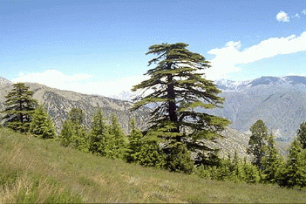
Chitral Gol National Park located in the north west of Chitral Town and is in the shape of a a huge mountain amphitheatre. Spread over an area of 7,750 hectares and established in 1984, the park has two hunting lodges, which were built by the Mehtars. The best time to go there is from May to September. Lammergier vulture, Himalayan Griffon vulture, Golden eagle, Demosille crane, Peregrine falcon, Himalayan snow cock, Himalayan monal, Snow partridge and rock Partridge are the most common birds found in the park. The park is also the habitat of markhor goats, the Siberian ibex, the snow leopard, the Ladakh urial (Shapu), the Tibetan Wolf, the Red fox, the Yellow throated martin, the Himalayan otter and the black bear.
Lakes of Chitral: There are four famous lakes in Chitral; Shandur Lake, Karbaza lake Chatti Bai Lake and Chiyan Tar lake. The first two lakes still exist while the other two have dried up. Lake Shandur is a beautiful spot on the border of Laspur Valley. Lake Karbaza is at Broghail in Yarkhoon Valley. Lake Chatti Bai is also in Broghail, but as mentioned earlier, it has dried up. Lake Chiyan Tar is another dried up lake in Lutkoh at Dorah Pass. Hot springs of brackish water force out their way at various places in Chitral, such as Lutkoh, Ambore, Treech, Boni, Shah Jinnali, Yarkhoon and Sindoor. People visit these in great numbers for the cure of skin diseases and asthma.
Snow blocks the pass from December to April. During this time, the Kunar road is the only way into Chitral. Opened in 1987, the road links Chitral and Kunar; it enters Afghanistan at Arandu. Running through the Afghan province of Kunar, it re-enters Pakistan through the Khyber Pass. The road remains open throughout the year, and its usage is made possible through an interim arrangement between the Chitral administration and Afghan authorities.
Ask anyone where Chitral is, and one may get a blank look since this land of Tirich Mir and the Kafirs, people of the lost world, is obscured behind the Lowari Top, which due to its inaccessibility generally keeps the tourist and holiday makers at bay. But those who dare to venture and reach out to Chitral Valley, find themselves in a different world - overlooked by the mighty Tirich Mir, standing at a height of 7,692 metres as part of the Hindu Kush mountain range, and located in the far reaches of Pakistan. Chitral is also famous for the Shandur Festival, which is held each year and where polo is played at the highest polo ground of the world at a height of 3,719 metres. The beauty of Chitral lies as much in its rustic, mountainous terrain, as in its warm hearted and friendly inhabitants. Since it is a land high up in the mountains, at such places legends fascinate the on lookers. One such legend describes Chitral as an abode of genies and fairies in times when no one lived here and locals still look up to the Tirich Mir, which they believe still has the castle of fairies.
Chitral forms Pakistan's north-western border with Afghanistan along the Hind Kush mountain range. The mountain passes that connect Afghanistan with Pakistan were the routes used by the Alexander the Great and his troops, who called the Hindu Kush "Parapamisus" meaning mountains over which no eagle can fly. After Alexander, Tartar hordes of Genghis Khan and Tamerlane also passed through, specially through the inaccessible Baroghil Pass (3,798 m or 12,460 ft) in the Upper Chitral (bordering the Wakhan Corridor of Afghanistan, which was once considered to be the rout to the famous Silk Route. Chitral has been traditionally and, except for a brief spell uninterruptedly, ruled by the Mehtars who claim themselves as ancestors the Tartar ruling family of Tamerlane.
The 322 kilometres long Chitral Valley located at an elevation of 1,128 metres. The Chitral district has Afghanistan to its north, south and west. A narrow strip of Wakhan in the Afghan territory separates it from the erstwhile Soviet Union and present day Tajikistan. Chitral Town, capital of the Chitral District, is situated on the west bank of the Chitral (or Kunar) River, with an estimated population of some 20,000, while the Chitral District has a population of about 300,000.
Being landlocked by mountain ranges, Chitral is only accessible through dozens of mountain passes, some of which are even more than 15,000 feet high. To the south, the dangerous jeep-able Lowari Pass (3,200 m or 10,499 ft) leads 365 kilometres to the region of Peshawar. In the north, the easiest route during summer (it is closed by snow in the winter), and the only one which allows the use of pack animals, runs over the Baroghil Pass (3,798 m or 12,460 ft) to Afghanistan's Wakhan Corridor. To the east, there is a 405 kilometres route to Gilgit over the 3,719 m (12,201 ft) Shandur Pass. And in the west, the Dorah Pass provides an additional route to Afghanistan. However, the easiest access to Chitral is in the southwest along the Chitral/Kunar valley towards Jalalabad (Afghanistan); this route is open all year and provides direct access to Kabul. However the Pakistan-Afghanistan border prevents this being used as an internal route to Peshawar and the south.
Places to Visit: The Kalash Valleys of Bumburet, Birir and Rambur, for the peculiar lifestyle of its people which is a living image of what the European community once was in the medieval age. This may be because this pagan tribe was set apart from the world for centuries and had lost interaction with its inhabitants, thereby following their unique customs, culture, and religion since 400 BC. And till now, the history and background of this primitive tribe and its 3,000 people is still shrouded in mystery.
Sites of Gandhara Grave Culture (Proto historic Period) - The grave burials date back to era in between the Indus Valley Civilization and the arrival of Achaemenian in 600 B.C. These graves assume tourist and archeological attractions for the reason that Chitral has never been a part of ancient Gandhara.
Forts and settlement sites of the 17th-19th centuries.
Bir Moghlasht, at an elevation of 2,743 meters (9,900 feet) and 15 km (9 miles) from Chitral, has the summer palace of the former Mehtar of Chitral. From the palace, one can get a good view of the river. The place also offers a spectacular view of Tirich Mir rising above and the valleys. A narrow winding road leads to the fort. Nearby is the Shahi Mosque of Chitral, was built by Mehtar Shuja-ul-Mulk about a century ago. It is a stylistic piece of architecture with its impressive inlays and decorations and its minarets and cupolas poised against a backdrop of a bleak, hilly landscape
