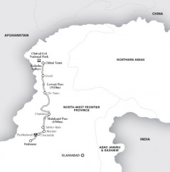
Geography of Chitral
Topographic features of Chitral:
Area 14850 - sq.km Glaciers /mountains - 76 %
Forests/Grazing lands - 20 % Crop land/Orchard - 4 %
COMMUNICATION
All weather road is the main problem of communication in Chitral. Pakistan International Airlines operates Fokker flights to Chitral on subsidized rates for locals and domestic tourists since 1962. Postal service is available in big towns and valleys. Electronic media such as television boosters, radio stations, and digital telephones exchanges have been installed in the district. Internet services have also been provided in Chitral since 2000.
Peaks in Chitral above 7000 m
No
Peaks
Altitude in meter
1
Terich Mir
7708
2
Nowshaq
7492
3
Istoro Nal
7398
4
Saraghrar
7349
5
Shegh Neik
7291
6
Darband
7219
7
Shakawar
7116
8
Nobiasun
7070
9
Langar
7061
Altitude of Important Towns
No
Towns
Altitude in feet
1
Chitral Town (HQ)
4980
2
Mastuj
7680
3
Bomborate
7596
4
Booni
7200
5
Drosh
4300
6
Arandu
3800
7
Susum
10300
8
Shagrom Terich
9648
9
Shongush Ovir
9611
10
Garam Chashma
7300
11
Brep
8300
12
Drasun
7000
13
Shagram Torkhow 7800 14
Madaklasht 8500
Glaciers
No
Glacier Place
Length in km's 1 Chiantar
Yarkhun 332
GazikistanArkari 28
3 Udren
Terich 18
4 Darkhot
Yarkhun 14
5 Pech Ouch
Yarkhun 13
6 Kotgaz
Yarkhun 10
7 Atahk
Terich 9
8 Kotal Kash
Yarkhun 8
9 Zindi Kharum
Yarkhun 8
10 Roshgole
Terich 7
Important Passes of Hindu Kush in Chitral
NoPasses
Altitude Between
1 Shandur
12305 Chitral & Gilgit
2 Kachi Kani
19292 Chitral & S3 Dodorgaz
17625 Chitral & Gilgit
4 Khatinza
17500 Chitral & Afganistan
5 Nuqsan
16560 Chitral & Afganistan
6 Zagar
16434 Chitral & Gilgit
7 Kan Kun
16360 Chitral & Afganistan
8 Agram
16031 Chitral & Afganistan
9 Darkot
15015 Chitral & Gilgit
10 Durah
14800 Chitral & Afganistan
11 Khrambara
14250 Chitral & Gilgit
12 Boroghil
12480 Chitral & Afganistan
13 Lawari
10500 Chitral & Dir
14 Chumarkan
14252 Chitral & Gilgit
15 Thui
14760 Chitral & Gilgit
